MapGrids is a program for converting between the Mapping Grids used in Australia, including AMG, MGA & WGS.
MapGrids may be used just for converting data in any supported grid, e.g. WGS84 – converting between – Decimal Degrees, Lat / Long, Eastings & Nothings.
(Microsoft Windows version only)
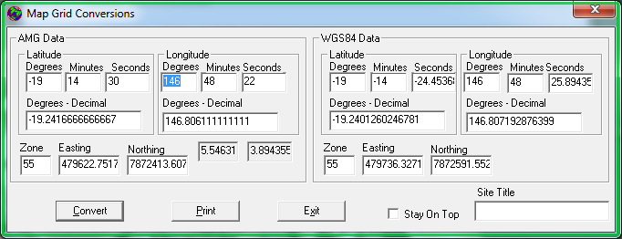
- The program performs immediate conversions, all values updated as you type
- Converts between Latitude / Longitude ( Lat / Long ) and UTM – Zone, Easting & Northing
- It converts between Australian Mapping Grid 66 AMG / AMG66 / AGD66 and Map Grid of Australia 1994 MGA / MGA94 / GDA94
The Geocentric Datum of Australia GDA94 is equivalent to commonly used World Grid System 84 WGS84 - AMG to MGA conversion
- Converts between Decimal Degrees and Degrees, Minutes & Seconds
- Converts Eastings and Northings to Decimal Degrees
- MapGrids is Microsoft Windows based
- MapGrids Converter Program is freeware
Using Mapgrids
Just download the Zip file and extract the executable to a folder.
Run the program.
As you begin entering data and move from field to field the conversion will be performed
and the other fields will be filled with data. E.g. If you entering data for Lats and Longs for
AMG data the conversion is automatically done to UTM (Eastings and Northings) for AMG, and also to Lats & Longs / Eastings & Northings for WGS84.
So from what ever mapping system you start with, conversion is done to the others systems automatically.
Remember to enter Australian Latitudes as negative values.
A printed report is produced by clicking the Print button. The Report title is taken from the text in Site Title field,
so that you can label and keep individual conversions as required.
If required, selecting the Stay On Top box, will keep MapGrids on top of any other programs you are using. Useful if you
converting lots of data, and switching between two programs.
Download the MapGrids program using the link below.
If you find the Mapgrids software useful consider making a donation through PayPal.
FAQ
Question 1. Why only AMG and WGS84?
Answer: The need for this program came from dealing with various paper maps where I work. And also applications and database systems
that used the multitude of grid systems as references. From what I researched AMG66 is used by most of our older maps and systems,
and WGS84 was now the world standard as far as GPS systems go. The newer GDA closely corresponds to the WGS84 system.
Question 2. Why didn’t program calculate the correct values?
Answer: Remember to enter Latitude values for south of the Equator as negative.
Online Version is available not available at this time
Only converts AMG Lat / Longs to UTM Zone, Eastings, Northings.
Experimental and under development but the current conversions are accurate.
Post comments to the form below.
Mobile versions
July 2009 – I am considering creating a mobile version of the Mapgrids program, Probably initially for the Apple iPhone and then maybe for the Nokia mobile, if possible. If you have any suggestions or specific requirements let me know using the feedback form.
References
Convert AMG Coordinates to Geographic
Geodetic Infrastructure – Datums
Australian Map Grid [AMG]
Geocentric Datum of Australia [GDA]
Geodetic Calculations – Redfearn’s Formulae, Geographic to Grid
Geocentric Datum Of Australia
I need conversion capability for Apple/ Mac or I Phone.. Is this available? .. Cheers, John..
Hi John,
Sorry I don’t have a Mac or iPhone version. It is something I was going to try, one day. I did have a web based converter before I changed my web site around. I will see if I still have it.
Ta, Graham
Hi, I am trying to plot a route marked on Wollangambe map
eg GR 479 027 is the start point at the locked gate
I would like to convert GR to a GPS to map a gpx route to import to a mapping app like Gaia
when I convert the GR coordinates I believe I need to add a 2 eg: 247900 and a 62 eg: 6202700
However the resulting conversion puts me in the High Range area of Nattai and not in the Wollangambe area.
What am I doing wrong????